Mythical Islands: Between Legend and Map
By Alex Mares | ANNO Media
For centuries, sailors and cartographers filled the blank spaces of the world’s oceans not only with coastlines but with dreams. Islands that never existed — or existed only in fleeting glimpses — appeared on maps, inspired legends, and shaped the imagination of explorers. Some of these places vanished as navigation became more precise, while others continue to haunt literature and art.
Hy-Brasil: The Vanishing Island of the Atlantic
Off the coast of Ireland, maps from the 14th to the 17th centuries often showed Hy-Brasil, a circular island shrouded in mist. It was said to appear once every seven years, then sink back into the sea. Irish folklore described it as a land of abundance, ruled by an immortal king. Explorers, including John Cabot in the 1490s, searched for it in vain. Though it never existed, the legend of Hy-Brasil fed into stories of utopias and “lost worlds” across Europe.
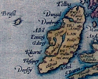
Detail of Abraham Ortelius 1572 map of Europe, depicting Ireland. The phantom island of Brasil is shown to the west.
Antillia: The Island of the Seven Cities
In Portuguese and Spanish charts of the 15th century, Antillia was placed somewhere in the mid-Atlantic. Its myth came from a tale of seven Christian bishops who, fleeing the Muslim conquest of Iberia, sailed west and founded seven cities on a distant island. When Columbus crossed the ocean in 1492, many believed he might find Antillia. Instead, the name survived in the “Antilles,” the Caribbean islands that bore the echo of the myth.
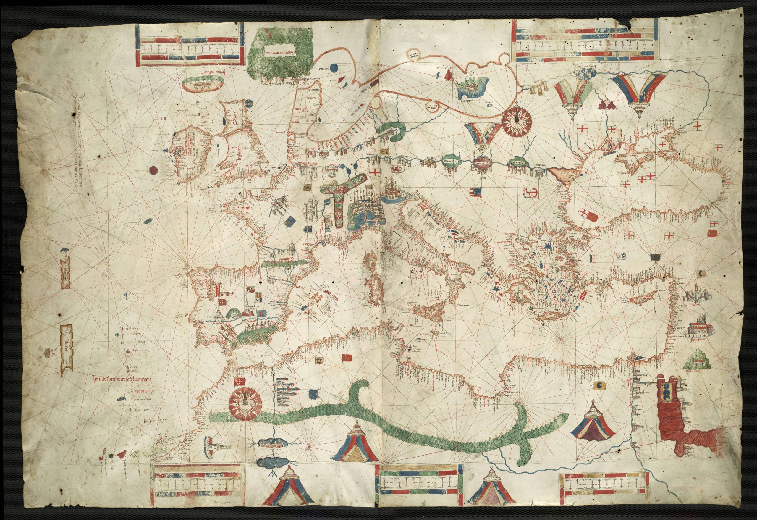
A full image of Canepa’s 1489 map, featuring Antillia (on the west) in relation to the Iberian Peninsula.
Frisland: A Cartographer’s Phantom
During the 16th and 17th centuries, numerous maps showed Frisland, a large island south of Greenland. It was described by Venetian sailors and appeared in influential atlases, even though no such land exists. Most likely, it was a misidentification of Iceland or Greenland, copied and recopied until it took on a life of its own in European imagination.
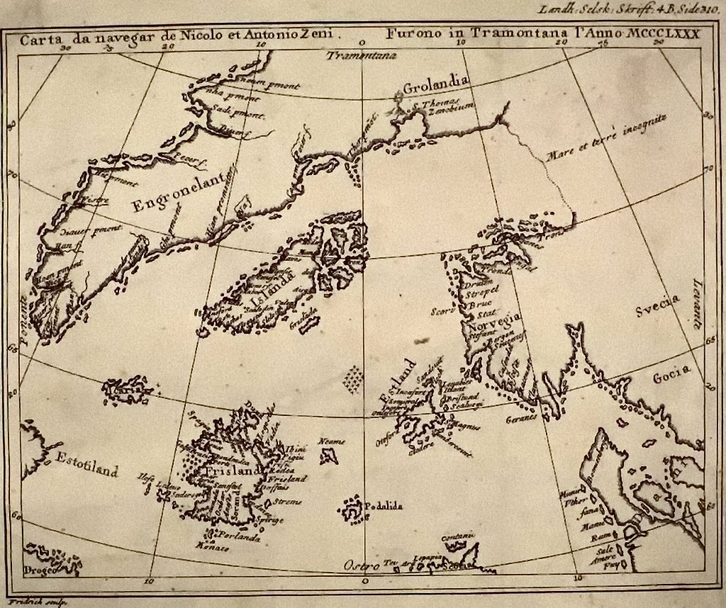
The Zeno map showing Frisland to the lower left
Islands of the Pacific: Between Myth and Reality
When European explorers first entered the Pacific in the 16th century, they too filled charts with uncertain islands. Some, like Terra Australis Incognita, were vast speculative continents, while others — like Isla de la Plata or Rica de Oro — blended rumor with reality. Japanese and Polynesian myths also spoke of paradisiacal lands: Hōrai, a fabled island of eternal youth, or Hawaiki, the ancestral homeland of Polynesian peoples.
The Allure of the Unknown
Why did mythical islands persist for so long? Partly because maps were as much imaginative documents as scientific ones. Cartographers relied on sailors’ reports, folklore, and hearsay. But myths also served a symbolic purpose: islands represented hope, sanctuary, or hidden knowledge. They promised another world, just beyond the horizon.
From Maps to Literature
Even after science erased these islands from charts, they lived on in culture. Writers and artists transformed them into metaphors — for utopias, lost civilizations, or unattainable desires. Hy-Brasil inspired modern fantasy fiction; Antillia echoes in the magical islands of Iberian literature; and Frisland reminds us how easily belief can give shape to the unknown.
Between Legend and Map
Today, digital satellites leave little room for phantom islands, yet their stories endure. They remind us that human curiosity thrives on mystery — and that sometimes, the places that never existed are as powerful as those that do.
Related Posts